

It is tempting, in the immediate aftermath of a natural disaster, to reach for a human culprit. The storm must have been triggered, the flood must have been engineered, the horror must have been avoidable. But before indulging that impulse, we must remember what has actually transpired. The floodwaters in Central Texas have not yet fully receded. Not all the bodies have been recovered, much less buried. We have lost more than one hundred souls, and the count is not yet complete. Among the victims are nearly two dozen precious little girls, lives full of promise cut short in an instant. It is a tragedy beyond imagination. Our hearts go out to the victims, the survivors, and the families left behind. They are in our prayers. If you wish to support the relief effort, I recommend making a financial donation to the Communities Foundation of the Texas Hill Country.
In the case of the catastrophic July 4 flash floods in Kerr County, Texas, which claimed over 100 lives, speculation has turned to Rainmaker, a private firm engaged in cloud seeding, as the supposed instigator. The theory sounds tantalizing: a high-tech plane, a deliberate act, and a short causal chain from silver iodide to tragedy. But the facts, when assembled and analyzed rigorously, offer no such narrative. Not only was Rainmaker’s final seeding operation far removed in both time and space from the eventual storm, but the physics of cloud seeding, the direction of water flow, and the sheer volume of the rainfall make any connection logically and scientifically untenable.
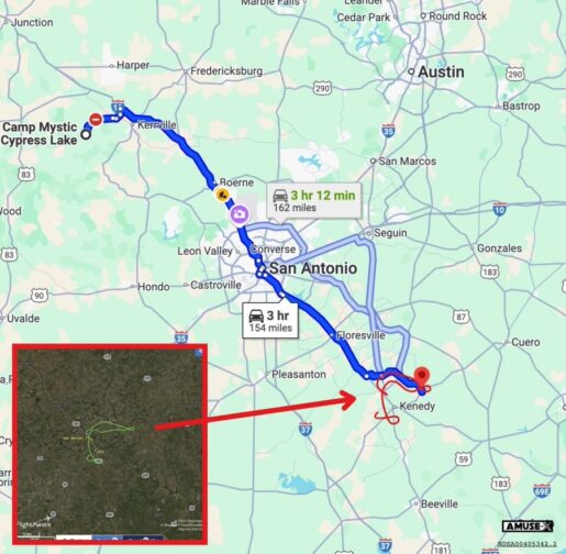
The flight path of the Rainmaker cloud seeding flight on July 2nd.
On July 2, between 1:01 PM and 1:21 PM, Rainmaker conducted a seeding operation over Karnes County near Runge, Texas. This location lies roughly 150 miles southeast of Kerr County. The clouds targeted were small, isolated cumulus towers, which dissipated entirely by 4:00 PM. The mission, according to flight logs and confirmed by the Texas Department of Licensing and Regulation (TDLR) reporting protocols, released 71.5 grams of silver iodide and 500 grams of table salt at an altitude of approximately 1,600 feet above ground level. The entire dispersal lasted less than thirty minutes.
To understand the scale, consider this: the entirety of Rainmaker’s July 2 operation released an amount of nucleating agent roughly equivalent to a measuring cup of table salt. Even if these particles had some hypothetical ability to travel upstream, uphill, and against the prevailing meteorological patterns for two days, they would have been so disbursed they would have been irrelevant by the time the first raindrops began to fall in the Texas Hill Country.
Cloud seeding, it must be said plainly, is not rainmaking in the biblical sense. It cannot conjure storms from thin air. Rather, it is a technique designed to induce marginal clouds to precipitate earlier or more efficiently than they otherwise would. It operates at the fringes of atmospheric potential, not at its center. The mechanism relies on introducing particles that serve as nuclei around which water droplets can coalesce. This hastens the natural life cycle of a cloud that is already inclined to rain. What it cannot do is summon an atmospheric river or intensify the sort of mesoscale convective system that characterized the July 4 floods.
Moreover, the hydrological profile of the flood event obliterates any suggestion of human involvement. According to multiple independent estimates, the rainfall that inundated Kerr County amounted to between 5.5 and 5.8 million acre-feet. That is enough water to fill Lake Powell. To attribute such an event to a cloud seeding sortie is to believe that a backyard garden hose filled an Olympic-sized pool.
Nor does the timing support the conspiracy. Rainmaker’s operations ceased on the afternoon of July 2. No flights were conducted on July 3 or July 4. Notably, on July 3 at 1:18 PM, the National Weather Service (NWS) Austin/San Antonio office issued a flood watch for Kerr County and surrounding areas, warning of the potential for heavy rainfall. The first flash flood warning came after midnight on July 4, over thirty-six hours after Rainmaker’s final seeding operation. In meteorological terms, that gap is enormous. Atmospheric dynamics evolve quickly and unpredictably, particularly when tropical remnants such as those from Storm Barry are involved. By the time the rains began, any seeding material would have been dispersed, diluted, or rained out, if not simply carried away toward the Gulf of America by prevailing southern drainage.
Indeed, this last point underscores a further flaw in the theory. Water, both in vapor and liquid form, follows gravity. It moves from higher to lower elevations, from the Hill Country to the coast. Rainmaker’s activity occurred far to the south, and any augmented moisture would have migrated, if at all, away from the eventual flood zone, not toward it. Meteorological models confirmed this: Barry’s remnants, embedded in a mid-level trough and drawing Pacific moisture, traveled north and west, colliding with warm, moist air from the Gulf. This confluence, not human agency, produced the conditions for the devastating storm.
During my fireside chat on X with Rainmaker CEO Augustus Doricko, a 25-year-old entrepreneur whose calm demeanor belied the storm of public scrutiny, we examined the data carefully. Doricko explained that the company’s operations are bound by stringent regulations set by the TDLR. These include immediate suspension of any seeding when flash-flood warnings are issued or when storms reach severe thresholds. The NWS had declared a flash flood emergency well before rainfall peaked. By then, Rainmaker’s planes were grounded, and had been for over a day and a half.
Doricko was transparent. He provided logs, material quantities, times, and coordinates. Everything matched. There was no indication of post-facto editing or omission. No evidence of rogue flights. No hidden flares or covert sorties. Rainmaker, to put it plainly, was not flying, not seeding, not involved.
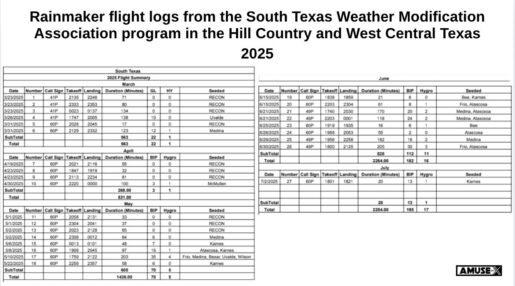
Rainmaker flight logs from the South Texas Weather Modification Association program in the Hill Country and West Central Texas – 2025.
This is not to say that cloud seeding is without consequence or beyond oversight. Like any intervention in natural systems, it merits scrutiny. But there is a vast gulf between scientific concern and conspiratorial scapegoating. If we confuse the two, we will fail both to regulate technology properly and to understand natural disasters on their own terms.
The July 4 flood was not a byproduct of silver iodide. It was the inevitable expression of converging meteorological forces, tropical moisture, mid-level instability, and nocturnal convection. It was, tragically, the kind of event that climate patterns increasingly foreshadow in a warming world, though still exceedingly rare in scale. And it was made worse by the reality that no warning system can perfectly predict when or where a cell will burst.
We are left, then, with the task of responding to the catastrophe without the comfort of a villain. There is no shadowy experiment gone awry, no secret button pushed in a plane. There is only nature, doing what it has always done: reminding man that his dominion has limits.
Those limits, however, do not excuse us from seeking understanding. They oblige it. Blaming Rainmaker for the Kerr County flood may satisfy the emotional need for causation, but it does nothing to prevent future tragedy. If anything, it misleads the public and misallocates the attention that should be directed toward improving forecasting, hardening infrastructure, and developing real-time emergency response protocols.
Let us not substitute technological suspicion for meteorological reality. The sky opened in Kerr County, not because someone asked it to, but because the air was heavy, the winds were right, and the Earth, as ever, did what it does best: astonish, overwhelm, and humble.
Texas Flood Timeline
July 2, 2025
- Afternoon (1:01PM to 1:21PM): Rainmaker conducted a cloud seeding operation over Karnes County near Runge, Texas (150 miles Southeast of Kerr County). Both clouds seeded dissipated by 4:00PM.
- Afternoon: Rainmaker flight logs confirm that no sorties were even attempted after July 2.
July 3, 2025
- Afternoon (1:18 PM): The National Weather Service (NWS) Austin/San Antonio office issued a flood watch for Kerr County and surrounding areas, warning of 1–3 inches of rain, with isolated areas potentially receiving 5–7 inches. The watch noted the possibility of heavy rain rates from scattered to widespread showers and storms.
- Evening: Weather models began to align, indicating a slow-moving storm system with potential for heavy rainfall. The NWS San Angelo office noted the risk of torrential rain due to a moist air mass, though the exact location and severity remained uncertain.
- Late Evening: The remnant mid-level circulation of Tropical Storm Barry, combined with tropical moisture from the east Pacific, became embedded in a mid-level trough, setting the stage for heavy thunderstorms over Central Texas.
July 4, 2025
- Midnight (12:00 AM): The NWS issued the first flash flood warning for Bandera County, indicating that flooding was imminent or already occurring. The Weather Prediction Center (WPC) forecasted extreme rainfall with hourly rates of 2–3 inches, warning of significant flash flooding risks in Central Texas.
- 1:00 AM: The NWS declared a dangerous flash flood event unfolding in Kerr County, with rainfall rates reaching 3–4 inches per hour.
- 1:14 AM: A flash flood warning was issued for Bandera and Kerr counties, tagged as “considerable,” triggering Wireless Emergency Alerts (WEAs) on mobile devices.
- 3:00 AM: Torrential rains intensified, with 4–6 hours of heavy rainfall (4–10 inches) already fallen in parts of Kerr County. The Guadalupe River began rising rapidly.
- 4:03 AM: The NWS issued the first flash flood emergency for Hunt and Ingram in Kerr County, urging residents to “SEEK HIGHER GROUND NOW!” as 4–10 inches of rain had fallen, with 2–4 inches per hour still expected. The Guadalupe River at Hunt rose to 21.99 feet, up over 10 feet in an hour, reaching major flood stage.
- 4:05 AM–5:10 AM: The Guadalupe River at Hunt surged to 37.52 feet, the second-highest level ever recorded, surpassing the 1987 flood. The gauge stopped updating, likely submerged. Multiple summer camps, including Camp Mystic, were catastrophically flooded. At least five campers (aged 8–9) and the camp director at Camp Mystic died, with a dozen others missing.
- 5:15 AM–6:45 AM: In Kerrville, the Guadalupe River surged from under 2 feet to 34.29 feet, reaching major flood stage. A flash flood emergency was issued for Kerrville at 5:34 AM, warning of “catastrophic” damage.
- 7:00 AM: Kerr County began evacuating residents near the Guadalupe River in Hunt due to 6–7 inches of rainfall causing major flooding. The Kerr County Sheriff’s Office reported “multiple fatalities” and urged residents to shelter in place and move to higher ground.
- 7:33 AM: The Kerrville Police Department posted on Facebook about road closures due to flooding, noting that severe weather was impacting July 4th events.
- 8:32 AM: Kerrville authorities posted on Facebook, urging residents along the Guadalupe River to “move to higher ground immediately.”
- 10:00 AM: The Kerr County Sheriff’s Office confirmed “catastrophic flooding” with multiple fatalities, declaring the entire county an active emergency scene.
- Afternoon: Search-and-rescue operations intensified, with 14 helicopters, 12 drones, nine rescue teams, and swift-water rescue boats deployed. Over 850 people were rescued, including 100 airlifted. The Guadalupe River was reported to have risen 26 feet in 45 minutes.
- 3:35 PM: The NWS Austin/San Antonio announced a flood watch on X, warning of continued heavy rain risks.
- Evening (6:10 PM): The WPC highlighted ongoing concerns for slow-moving, training thunderstorms in south-central Texas, with rainfall rates exceeding 3 inches per hour possible into the night.
- Night (7:04 PM–10:51 PM): Camp Mystic reported catastrophic flooding, with 23–25 girls unaccounted for out of 750 campers. Texas Governor Greg Abbott signed a disaster declaration for multiple counties, including Kerr, Bandera, and Kendall, to mobilize state resources. At least 24 deaths were confirmed in Kerr County, with one additional fatality in Kendall County.
July 5, 2025
- Early Morning (1:14 AM): A flash flood warning was issued for Bandera and Kerr counties with a “considerable” tag, indicating high-damage threats.
- Morning: Flash flood emergencies and warnings continued, particularly around Lake Travis in the Colorado River watershed. Search-and-rescue operations persisted, focusing on Camp Mystic, where at least 27 girls remained missing.
- Afternoon: The death toll rose to 32, including 14 children, with 43 deaths reported in Kerr County alone. Texas Lieutenant Governor Dan Patrick noted that emergency resources were pre-positioned but overwhelmed by the rainfall’s intensity.
- Evening (5:00 PM): Texas officials reported 850 rescues, with ongoing efforts using helicopters with infrared technology to locate survivors. The death toll reached 78, with 68 deaths in Kerr County (including 28 children) and 10 in surrounding counties.
- Night: Governor Abbott expanded the disaster declaration to include six additional counties. Search-and-rescue operations continued 24/7, with ground crews, boats, and dogs searching the Guadalupe River.
July 6, 2025
- Morning: The death toll climbed to 80, with 68 in Kerr County, six in Travis County, three in Burnet County, two in Williamson County, and one in Tom Green County. At least 41 people, including 11–27 girls from Camp Mystic, remained missing.
- Afternoon (3:00 PM): President Donald Trump signed a major disaster declaration for Kerr County, as requested by Governor Abbott. Rescue efforts continued, with over 160 air rescues and 223 people saved by the U.S. Coast Guard.
- Evening (6:00 PM–9:00 PM): The death toll reached 82, with 41 still missing. Flash flood warnings persisted for Central Kerr County, and a flood watch remained for parts of the Hill Country until 7:00 PM. Thunderstorms shifted east toward the Interstate 35 corridor, reducing flooding risks in the Hill Country but raising concerns for Austin and San Antonio.
- Night (11:27 PM): The flood watch for the Hill Country expired, but flash flood warnings remained for parts of four counties, with 1–2 inches of additional rain expected.
July 7, 2025
- Fireside chat on X Spaces with Rainmaker CEO Augustus Doricko.
If you enjoy my work, please consider subscribing https://x.com/amuse.