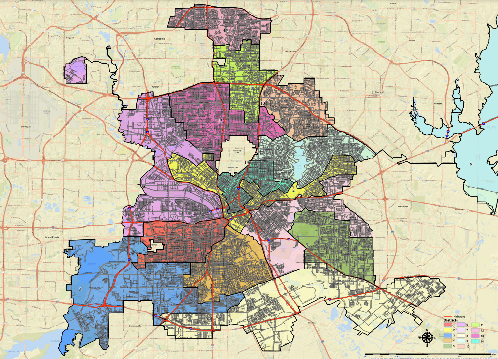
After months of work, dozens of public meetings, and a whirlwind last several days of hearings, the Dallas Redistricting Commission on May 10 finalized and approved a new map delineating the districts to restructure local politics in Dallas for the next decade. The map, known as 41B, passed by a vote of 10-5 after an alternative map, 17B, failed 7-8 earlier in the day.
The newly-drawn map will be forwarded next week to the mayor, who will then present the map to the Dallas City Council for final approval. This was the first time in the city’s history that online software was provided to allow citizens to draw their own maps — a critical step in the process of identifying how and why district boundaries should be set.
The U.S. Constitution states there can be no more than a 10% difference in population from one district to another. The map approved on May 10 has an overall deviation of 9.06%, keeping within the scope of the law. In all, 42 neighborhoods in the same districts will now be split into new districts.
The redistricting process determines where the boundaries for the voting districts will lie and which districts neighborhoods will vote in. Among the many factors considered were significant assets like Dallas Love Field, shopping and dining areas, and minority communities.
The Commission reviewed more than fifty maps and heard from over 1,200 community members to determine how the final map would be drawn. The process was at times contentious, with many members of the public and commissioners discussing personal experiences and grievances.
At other times, the process was heartwarming, like when the 9-year-old daughter of Bill Betzen, who is a regular participant in redistricting and has had at least ten maps accepted for consideration, presented her own map that met all of the requirements laid out by the Commission and gave the members important perspective about the value of public participation.
Ultimately, most of the discussion fell on how the group of 15 men and women would manage the population changes in Dallas since 2011, when the last map was drawn. Some areas have seen near-unprecedented growth, with residents in two Hispanic districts increasing by more than 12,000, while some areas in South Dallas saw their population decline.
The map that finally was chosen was drawn by Commissioner Norma Minnis and had significant amendments by Minnis and Commissioners Randal Bryant and Brent Rosenthal. It keeps the Northern and Southern Districts largely intact but makes modest changes to Districts 1, 2, 9, and 14.
The push to conclude the process began with private meetings on May 7 and picked up with public hearings on May 9. The Commission heard testimony that day from 3:30 p.m. until nearly midnight before reconvening on May 10. Members spent at least three hours on Tuesday debating amendments before participating in the final vote to select 41B.
Sources: all information taken directly from the commission hearings beginning on May 9 and continuing through May 10. I have calls out to all of the members seeking comment and will provide an update if/when I hear back.